Be Bold, Climb Mt Baldy in Winter
Mt Baldy, officially named Mount San Antonio (10,046ft 3,068m) is the highest point in the Los Angeles area and not surprisingly is a very popular hike in the Summer. It is also considered a perilous mountain, especially during winter conditions. It is also famous for claiming Hollywood Celebrities among its victims.
Frankly, I’m not surprised – mild weather on Los Angeles Area beaches may encourage you to go hiking in a T-shirt and shorts, as the trailhead is just about 1 hour away (if you can avoid famous LA traffic) while of course it can be anything but. It is deceptive mountains that claim a lot of beginner hikers’ lives, not hard ones.
I was attending South California Linux Expo in Pasadena, taking place in the middle of March, and came up with the idea of summiting Mt Baldy as I needed an endurance workout and this summit trail – almost 8 miles with almost 4000ft elevation gain fit the bill.
The Hiking Guy has a very good article on Mt Baldy. Checking suggested web cameras and weather forecast, checking recent accents on Alltrails I found there is a lot of snow on the mountain, it is icy. The weather forecast showed there will be some fresh snow, cold and windy, making it a fun kind of challenge.
Equipment
I was not going to climb Mt Baldy in Shorts! I had my favorite La Sportiva Bushido II trail runners, Ultralight Gaiters, and some Micro Spikes from Amazon. I forgot to bring my Trekking poles so I stopped by to buy those in the REI store as well as pick up some snacks. I also had my soft shell trekking pants and packable down jacket with me which provided enough layers.
Ascend

I love starting in the dark, trails are so peaceful at this time of day and also things look very different in the dark. I was on the trail by 5 AM – drive and parking were very easy. The trail starts as a paved road, closed to car traffic which is very easygoing. I was so consumed by the walk I missed the turn from Baldy Road to Mt Baldy trail, only checking it quite a bit later, costing me about a 30-minute detour.
The trail is moderately steep and easy to find even in the dark. Very soon you could see fresh snow on the ground as well as a little bit of snow falling from the sky. In some places, the trail was completely covered and you could see multiple paths of people navigating the terrain not following the trail exactly.
In about 1 hour 45 minutes, I reached San Antonio Ski Hut – As I learned later you can stay in this place overnight if you want to split your summit push or need to acclimatize. I met a couple of hikers having breakfast on the stairs and got an update about conditions on the mountain. There is a great view on the ridge from the ski hut and I could see a fair amount of headlamps on the slopes… the top of the month was covered by fog and clouds. They also told me because the trail is fully covered by snow many folks are not following it but rather finding their path on the slopes.
It was the time to put on my microspikes.

As I’m not familiar with the mountain and especially the avalanche situation, I decided to stick to the main trail when possible. Relatively quickly I caught up with a skier taking a shortcut climbing one of the faces directly – I followed him and caught up with him quickly. He told me to get up to the ridge and follow it almost to the summit.

The slopes were pretty hard ice, covered with a very thin cover of fresh snow, but as the slope was not very steep it was rather comfortable climbing with trekking poles and microspikes. It was also bright enough by this point so I did not need my headlamp.
The trail in this place takes a bit longer route going through the trees and even less steep terrain.
As I got on top of the ridge It was getting colder, there were unpleasant gusts of wind, throwing snow in my face. This also ensured you could hardly see the trail, yet staying close to the top of the ride was easy enough to navigate.
After another 100 vertical meters or so you enter the cloud which rather quickly turns to a complete whiteout. I mostly followed the route to the summit by GPS – visibility was so poor it was hard to know if you were at the Summit or if it was just a flattening of the slope.
There was a bit of post-holing required though nowhere the snow was more than knee deep.
A few minutes from the summit I met the only group that seemed to have summited before me – all of them had helmets, real mountaineering boots, and crampons as well as ice axes, it looked like they were using this opportunity for training.
No views and even stronger winds on the summit meant I did not spend a lot of time out there but took a couple of pictures and went back down.

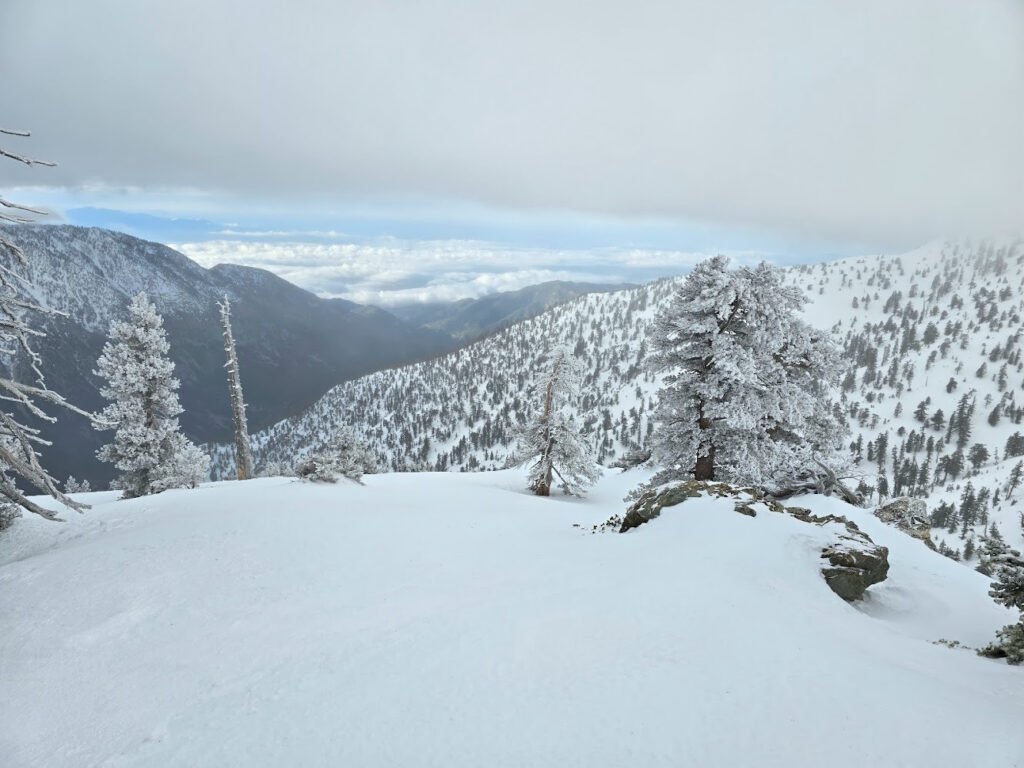
On the way down I got out of the cloud pretty quickly and snow stopped, opening up much better views than early morning. Ice-frosted trees were gorgeous.
I also spotted a group of climbers going up through the steeper face, using ice axes and everything so it looks like an easily accessible spot to try some ice climbing in winter.

By the time I made it back to San Antonio Ski Hut, about 9 AM many people were going up the mountain – the trail was much easier to find and conditions on the top looked more pleasant. At the same time, this fresh snow which fell during the night started to quickly melt at lower elevations.

Going down I kept my microspikes below San Antonio Ski Hut, only removing them halfway down to the trailhead.
By 10 AM I was down to the car and went back to the conference
Takeaways
More challenging “winter” conditions surely made it a more interesting hike than it would be in summer conditions. Though next time I’m in Los Angeles in summer it would be fun to go and do a run to the top. Also, now I have a feel for what Mt Baldy looks like in Winter I will consider getting a group of friends together to do a group hike after South California Linux Expo.
